Skip to main content
Please wait...
Main navigation
Home
Explore
Geographic Origins
Categories
Search
About
Introduction
How to Use this Website
Acknowledgements
Resources
Introduction to “Ornithology in Peale’s Museum”
Du Simitière Sources
Peale Sources
Geographic Origins: North America (East)
Category: Printed Works/Manuscripts
Reset Search
Displaying 1 - 4 of 4
A very elegant Map of the Island of New York
A Map of the State of Delaware drawn by Edward Simmons Lewis aged 6 years executed with the Penn
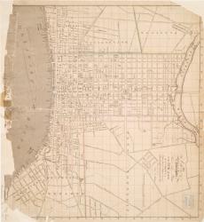
A New Map, of the City of Philadelphia and a pamphlet
24 Maps of different ports harbours and Islands of America. in French
Download CSV
Category
Show all
(4)
(-)
Printed Works/Manuscripts
(4)
Pamphlets
(1)
(-)
Maps
(4)
Geographic Origins
Show all
(4)
(-)
North America (East)
(4)
Donor
(-)
Show all
(4)
Dorfeuille, Joseph
(1)
Gilpin, Thomas
(1)
Lewis, Samuel
(1)
Paxton, John Adems
(1)
Collection
(-)
Show all
Charles Willson Peale
Category
Show all
(4)
(-)
Printed Works/Manuscripts
(4)
Pamphlets
(1)
(-)
Maps
(4)
Geographic Origins
Show all
(4)
(-)
North America (East)
(4)
Donor
(-)
Show all
(4)
Dorfeuille, Joseph
(1)
Gilpin, Thomas
(1)
Lewis, Samuel
(1)
Paxton, John Adems
(1)
Collection
(-)
Show all
Charles Willson Peale